Positioning the points of sale or branches in the locations most convenient for customers is vital for retailers and catering companies, financial institutions, and service providers. Another important thing they need is analyzing the locations of their competitors' branches. Geoanalytics allow business executives to refine the directions of development, analyze the business profitability in specific regions or city districts, optimize logistic routes, learn about the opening of competitors' stores, and thus ensure the company's growth.
Geoanalytics in retail networks
Any retail chain strives to increase its coverage and open new stores, as each new point provides the company with additional revenue and income. It is crucial to open a shop in the right place, especially if the company does not operate in the current region.
Large and experienced retailers have developed checklists covering several dozens of parameters that are taken into account when opening a new branch. These parameters may include the traffic of potential consumers, so the most promising locations are considered to be close to traffic interchanges and stops. Stores are opened mostly on the first line, on busy streets, or dormitory districts.
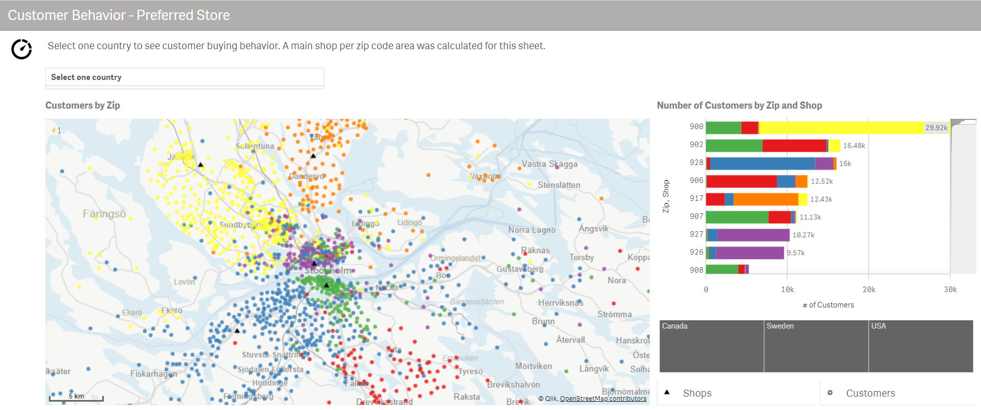
Another point of interest for retailers is the level of potential buyer income and the number of inhabitants living within a certain radius. There are a lot of such parameters, and geoanalytics provides information on most of them by representing various kinds of data on maps with georeferencing. If you analyze geographical locations and consider their link to additional parameters, classical analytical tools such as charts and graphs fail to accurately represent the geographic location of your stores. Therefore, analysts from retail networks visualize their insights on maps to increase the efficiency of making such decisions.
Geoanalytics can go beyond the information available inside the company—you can buy external services providing relevant data on population size, the average income, transport capacity, and flow of pedestrians and potential buyers. Comprehensive solutions are usually based on Business Intelligence tools. They use the georeferencing functions to unite the internal data of the company and data received from third-party services and the external market.
Point of sale performance analysis with geoanalytics
For example, the company has 40 shops in the city of approximately the same format, with an identical assortment, promos, and prices. But at the same time, these stores have unequal efficiency: the revenue from the sales of certain goods and the product shelf life often vary, resulting in different volumes of profit. To understand the difference between the points of sale and the decisions that need to be made, internal data (such as the product remainders in a particular point of sale, promos, and training activities) are not enough, and the company must further analyze external information, e.g., the presence of competitors' outlets.
If this information is presented as a table or a list showing the distance to a competitor's point of sale, it would be somewhat incomprehensible. But when you visualize these data on a map, you can drill down to each specific case, analyze the pedestrian sheds, evaluate the proximity to the nearest pedestrian or transport routes, assess the availability of parking spaces, convenience of your and your competitors' store location. This improves the quality of decisions on development strategy and actions for a specific point of sale.
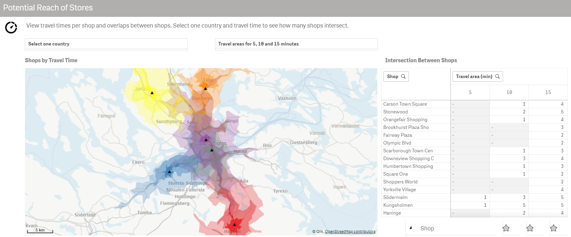
If you understand that the location of your store is lackluster compared to that of your competitors and that it is impossible to ensure proper traffic, a wise decision may be to relocate this point of sale. If a particular point does not have as many competitors as others, then the set of measures is very different. Pay attention to internal factors (for example, the work of the staff, the merchandise display) and try to raise efficiency through internal organizational measures.
Development of itineraries for logistics companies
Geoanalytics can also solve logistics tasks: developing itineraries for the delivery of goods to points of sale or optimizing the activities of sales representatives. Various modules of the system simplify the planning of logistics flows, delivery, and activities of sales representatives. These modules build and select the optimal routes, so the life of logisticians becomes much simpler. But nevertheless, they need tools to display the above data on maps for visual control or to determine how to optimize the algorithms of their systems.
Optimization of pickup point performance
If we talk about online orders and companies working in the field of e-commerce, geoanalytics can be used to plan and optimize the location of pickup points. When a customer places an online order, geopositioning data analysis tools make it possible to collect information about the customer's location down to the city district or even house and generate a heat map that will show where and how often online orders are mostly placed and what is their average sum.
With the information shown on the map, it is easy to make reasonable decisions on where to place additional pickup points, increase their density or number. The same logic can be applied to the networks of parcel terminals, which have recently become an emerging trend. You can use geoanalytics to optimize the location of parcel terminals, install additional parcel terminals, and use other points for their placement.
Competition analysis
Other applications include the competitor analysis to make decisions to change or refine the format of stores located in certain areas. If you map information of your own and your competitors' networks and compare the sales figures (volume, average bill, and frequency of purchases) with the population density in a particular area, you can determine the effectiveness of one or another point of sale format in a specific location. Sometimes you may choose between discounters and top-class retail stores with a wide product range and high prices. The presentation of internal and external market information on the competitive environment on maps will help you make an effective and reasonable decision.
Pharmaceutical business and pharmacy chains
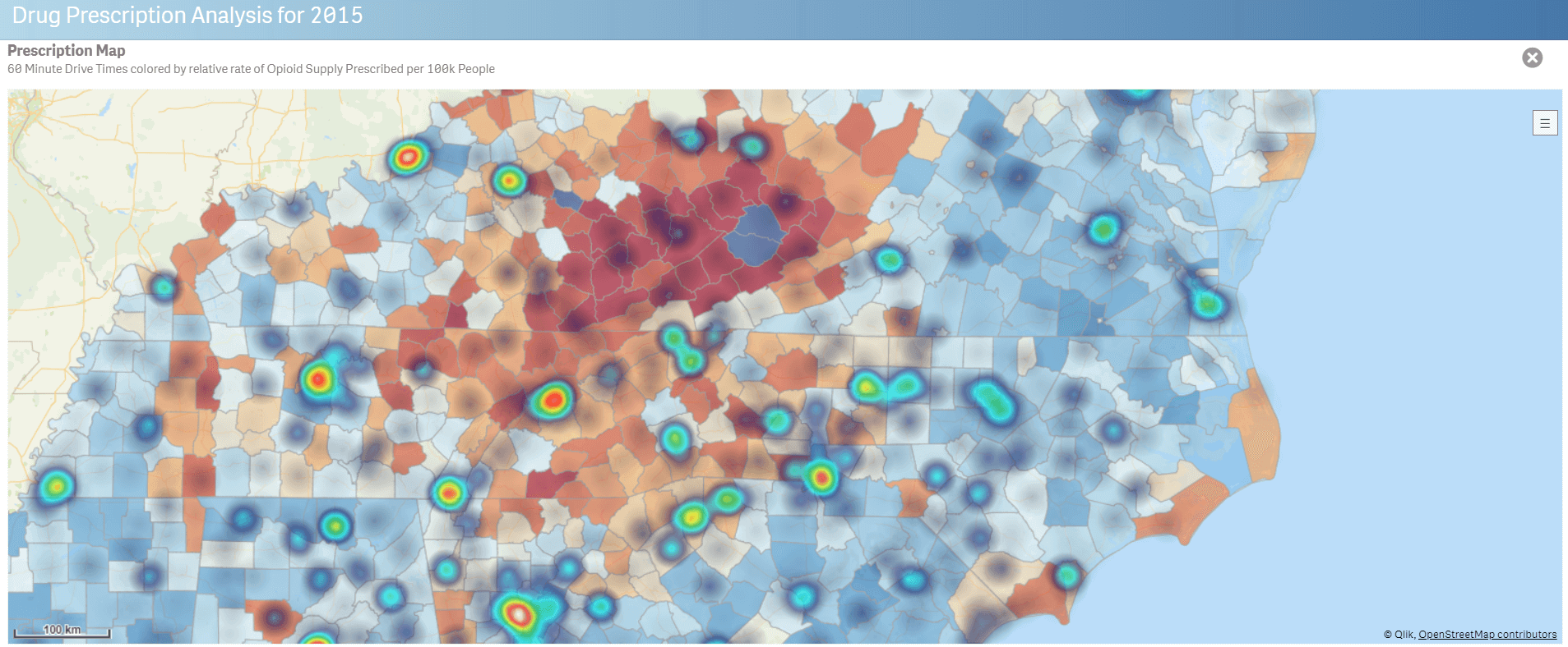
Geoanalytics makes it possible to solve the tasks of pharmaceutical business and pharmacy chains: forming product mixes in pharmacies and paying increased attention to a certain group of drugs, especially if this applies to pharmacies located near specialized healthcare facilities. If a pharmacy is located close to one healthcare facility, geoanalytics makes it possible to reveal the most demanded group of drugs, pay special attention to the lack of stock, and continuously monitor it to ensure that there are no missed sales.
Qlik Sense and Qlik GeoAnalytics
Softline cooperates with Qlik, a leading developer of Business Intelligence solutions. Its products, Qlik Sense and Qlik GeoAnalytics, have become the gold standard for retail analytics in Russia. They are used in such companies as Magnit, Lenta, X5, Detskiy Mir, etc. These applications combine different business intelligence capabilities to retrieve data from multiple sources, combine them into a single model, and provide users with a user-friendly data management tool. These solutions have both built-in tools and additional plug-ins that present geoanalytical data in different layers on maps. They can define links to specific areas or points on the map. With these business intelligence platforms, you can easily distribute data between different layers on the map, analyze the output, and quickly reveal the existing patterns.